| 
 Tourism Saint-Louis Senegal Tourism Saint-Louis Senegal
Once you cross the Pont Faidherbe bridge you discover a society whose life style and conviviality are unique. A city of great structural wealth, bearing witness to its glorious past. By foot or riding a carriage through the streets whose evocative names (Repentigny, Anne-Marie Javouhey, Blanchot, Pierre Loti...) remind of times past, you can admire the city's sites following the urban walk created by the Initiative Syndicate of Saint Louis.
Coming from the district of Sor, on the continent, you can access the island of Saint-Louis only by one link, the Pont Faidherbe bridge. This metallic structure is 507 meters long and 10.5 meters wide. The bridge of Saint-Louis consists of 7 arched spans with the second to last having been conceived to pivot around a fixed axis to let ships pass through. Two wooden sidewalks border its central pass-way. Over one hundred years old, this bridge was first inaugurated on October 19, 1897.
Once you have crossed the Pont Faidherbe bridge, a large complex, communally known as the gouvernance, which contains the region's administrative offices, dominates your view. Inherited from the old fort are the thick-based walls, a vestige of the old buttresses that can be seen from the Mille Lacroix Street.
To the west, the gouvernance opens on a shady square, named after the governor Faidherbe, whose statue towers over the gardens. This communal space, used for the city's festivities, is bordered to the north and the south by two originally identical buildings. They are the old barracks of Orleans (baptized Rogniat) and they used to hold the military garrisons. On each side of this central square are the island's two districts, the South or Sindone and the North, or Lodo. During the itinerary, you can discover the old edifices and the city's typical architecture.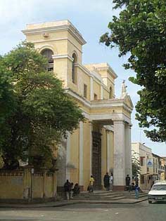
As you turn to the South, the first zone of European settlement, also called kertian (from the French chrétien, or Christian), you will find the cathedral, just around from the gouvernance. Consecrated in 1828, it was the first church in West Africa. You can admire its neoclassical façade, its advanced porches and its pediment surmounted by the statue of Saint-Louis.
Towards the "Grand bras", or the large branch of the river Senegal, you can distinguish a beautiful white building with richly ornamented wrought iron balconies. Originally the siege of the General Council, it later became home to the Colonial Council, then the Territorial Assembly, the Regional Assembly and recently the Regional Cultural Center. Once you enter through its heavy wooden door, you can observe the superb wooden ceiling with its painted coffers.
 Heading towards the southern tip of the island, you will discover the old house of the Saint Joseph de Cluny nunnery, which has now become the Regional Revenue Service. Its monumental staircase, with two circular and symmetric wings, is one of the more architecturally interesting originalities of Saint Louis.
Before coming to the southern tip, you can stop by the Ameth Fall High School, whose buildings were built in 1840 on the site of the first Christian cemetery. These walls have respectively held the civil hospital and then the Blanchot School before becoming a girl's High School. Its magnificent courtyard, and the balance of its architecture make it a soothing learning environment.
Touching the High School is the more modern building containing the Center for Research and Documentation of Senegal (CRDS), which used to be the French Institute of Black Africa (1954). The center is home to an important library, containing countless archives on the A.O.F. (French West Africa). As well, don't miss a visit to the museum and the modern art gallery.
From the CRDS esplanade, there is a beautiful view on the river as it flows towards its mouth. The district across this expanse of water, on the Langue de Barbarie is the fishing village of Guet Ndar. Every year they organize regattas on this river. Further behind are the fisherman cemetery, and the Hydrobase, from which Jean Mermoz left for his historical journey across the Atlantic. To the East are the more recent districts of Sor, the modern Saint Louis.
Come back towards the Northern district along the banks along the large arm of the river. Started in 1830, the construction of these embankments, surrounding the island, were initiated by Faidherbe, to be finally achieved by Roume. First made of wood, and later masonry, they assured the use of the banks as well as offered protection against flooding.
On these embankments were loaded and unloaded the countless merchandise that were central to commerce along the river. Warehouses, aligned one after the other, especially on the northern banks, are a testimony to past prosperity. These commerce houses, owned by families from Bordeaux or Marseilles, generally occupy a whole city block, with a closed off central courtyard; warehouses stocking various merchandise on the river side, and stores on the street side, usually with large wooden doors. Above were the family's apartments and servant quarters, with vast balconies and balustrades.
At the end of the docks, after the French School, is a tall metallic silhouette. It is a 20 ton steam crane. A witness to the fluvial traffic of the time, this steam engine is one of the few remaining of its kind.
 From the crane, you continue towards the interior of the North, penetrating into the military quarters. All along the Jean Mermoz Avenues are a succession of military style buildings: the French Consulate and its annexes, the firemen barracks, the military supply corps... From the crane, you continue towards the interior of the North, penetrating into the military quarters. All along the Jean Mermoz Avenues are a succession of military style buildings: the French Consulate and its annexes, the firemen barracks, the military supply corps...
Further away, to the left, the El hadji Omar camp used to hold the ancient armory and was the barracks of the infantry corps called "Tirailleurs Sénégalais" (Senegalese sharpshooters).
From the northern point of the island, looking upriver, you can see the island of Bopp Thior where the first brick factory of the region was located.
Coming back downtown at the limit of the Avenues, the Grande Mosquée, of Maghrebin style, was built by the colonial administration for the growing Muslim population. The bell tower, lodged in the mosque's minaret remains an enigma.
Closer to the center of town, two neighboring buildings stand on the Marie Parsine Abdoulaye Seck Street (ex Brière de l'Isle): the Palace of Justice, built in 1841 and whose monumental wrought iron staircase is greatly admired, and the Military House whose architecture is so well preserved. This last building is said to have been erected on the ancient site of Governor Schmaltz's house, who himself is a survivor of the famous "radeau de la méduse."
All along the path, you will notice the typical character of the city's houses. They are firstly two storied houses with tiled roofing; on the ground floor large rooms primarily used as shops, opened to the street through large wooden doors. On the street side as well as in the courtyard, lined apartments with high wooden ceilings open up to balconies with wrought iron balustrades. The inside of these rooms offers a good respite from the heat. We can also imagine the tranquil life lead by the Signares, the famously beautiful women of both European and African descent that inhabited these houses.
Further away from the center of town, in the North as well as the South, are the low houses, said of Portuguese style. Generally smaller and built in concrete, they are covered by red tiled roofs, usually with two slopes. You can access these through a decorated porch and a wooden doorway. Inside, the aligned rooms open up on a cool veranda.

|
|
